Wednesday, November 21, 2012

Georgia

In November 2012 I had to travel to Atlanta for work, so I took off a couple of days and did some riding within a reasonable driving distance. My first ride took me to Franklin, NC. My second ride was the famous Six Gap Century in Dahlonega, GA

Dahlonega, GA
The Route
The Six Gap Century was an easy choice for me. I've heard a lot about the ride and I've had this ride in the back of my mind for a while now. My only regrets were that (a) I couldn't ride this in the warm summer months and (b) I was running short on time, so I didn't get to add in the Brasstown Bald climb. Aside from that, it was a perfect ride. It's a good mixture of a challenging route plus great scenery. Traffic was relatively calm and there was plenty of sunshine.

I would definitely recommend this route to anyone who is visiting Atlanta. The cue sheet is posted on the event website and it's easy to follow. As a bonus, the Dan Henrys were still clearly visible while I was riding. I rented a bike from CycleWorks, which is in between the ATL airport and Dahlonega. I was pleased with the experience. They have an easy online reservation system, the bike was solid, the people were nice, and the price was right.

Hogpen Gap was easily the most difficult climb of the day. It has a few short downhill sections where you think the climb is over, but it's not. I'd love to try it in the heat of the summer.


Runaway truck ramp- different from the one's I'm used to on US 50 near Carson City.


Rental Bike


Rental Bike

Camera malfunction

Camera malfunction
Update: I rode across Georgia as part of my ride across the country in 2015. Here are the relevant days: 21, 22, 23. You can find more pictures plus the Strava links to the route.

North Carolina

In November 2012 I had to travel to Atlanta for work, so I took off a couple of days and did some riding within a reasonable driving distance. My first ride took me to Franklin, NC.

Franklin, NC
I wanted to ride the mountains in the southwestern corner of the state, and I came across the route for the Nantahala Nightmare. I modified the route a little bit (with to park and start in Franklin itself) and ended up with this:


The route was a little bit under 100 miles, but I figured I might accidentally go off route somewhere along the way to make up for it. Sure enough, I missed a turn towards the end as I was heading back to Franklin and ended up with 104 miles.

I started out early under a cover of clouds. It was cold out, but the main climb of the day started at about the 10-mile mark, so I wasn't cold for long.

Cloudy start
The first climb behind my shoulder.
The temperature rose and the clouds cleared as the day went on. I may have missed the peak fall foliage season, but there were still a few colorful trees out there and I didn't have much traffic to worry about.


Waterfall


Rental Bike

Rental Bike


Tuesday, October 9, 2012

Texas

With a state as large as Texas it's difficult to make the decision where to ride. Hit a big city (Dallas, San Antonio, Houston), see the Gulf of Mexico, ride out in the middle of nowhere, or check out Big Bend National Park? I considered all of those options, but in the end I went to the Texan city that I hear cyclists talk about the most- Austin.

My route of choice was the Tour das Hugel route, a difficult ride through the hills of Austin that's been featured on Pez (http://www.pezcyclingnews.com/?pg=fullstory&id=7774). I wasn't doing the official ride, just riding on my own and using the cue sheets from the website.

I flew in to AUS and rented a bike from Bicycle Sport Shop. The price was right and they had the Specialized Roubaix available, which seems to get great reviews. I wanted to see if it would live up to the hype.

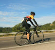
The rental bike for the day.
Maybe I'm too picky, but I don't seem to have good luck with rental bikes. This one was dirty and didn't come with a computer. I brought my own pedals, tires, saddle, pump, tools, and bottle cages, but didn't think to bring my own computer. I'm not a slave to the data, but having a computer would have made following the cue sheet easier. On the plus side, the people in the shop seemed nice enough and I got lucky with the seatpost position and didn't have to adjust it at all.

The ride starts at Zilker Park on Stratford under the MoPac. As luck would have it, Stratford was closed, so I had to start somewhere else in the park and got the feeling that I was going to get lost somewhere along the way.

A morning view from SR 360. The picture isn't great, but that's downtown Austin in the background.
The rental bike and Austin.
The first loop (38 miles) went by with no problems. It was mostly rolling hills through residential areas. There were some steep sections, but they were never very long and it was still early, so I felt good.

The second loop was both more scenic and more difficult. I'd say the most difficult part of the day had to be Beauford Dr/Jester Blvd. The climb there was steep and seemed longer than most, plus the grooved pavement added a bit to the difficulty.

Colorado River- early in Loop 2


Beauford Dr- the toughest part of the day.

Mansfield Dam

Mansfield Dam

Big View Dr
I managed to make it through the whole day without getting lost or making any wrong turns. Doesn't sound like much, but that's always an accomplishment for me when I'm going off of a cue sheet in an unfamiliar area. The route itself was great. Traffic was light most of the day and the sections on 360 had more than enough shoulder. I saw quite a few cyclists out there and from the short time I spent there, Austin does seem like a bicycle friendly city. If you're looking for a ride in Texas I don't think you can go wrong with Austin, and I highly recommend the Tour das Hugel route.

Update: I rode through a portion of Texas on my ride across the country in the summer of 2015. Here are links to the relevant days: 12, 13. You can find the Strava Links to the route I used, which is actually safer than it looks because those highways have large shoulders.

Monday, July 23, 2012

North Dakota

I traveled to North Dakota in July 2012 for a nice ride along the Missouri River on highway 1806.

Bismarck, right in the middle of North Dakota.
My route took me straight from my hotel in Bismarck through Mandan and south on 1806 (Google map: http://goo.gl/maps/KEKR). I can't say that there is anything I would have changed about the route. I normally prefer a loop to an out-and-back, but 1806 was a great road and it was worth seeing twice.

The route.
I didn't do much riding in Bismarck itself, but from what I saw it seemed fairly bicycle friendly. I came across some sharrows on Rosser Ave and other bike paths along the way as I went through Mandan towards 1806. Crossing the river was easy on Memorial Hwy with a nice and wide separated pedestrian path on the bridge.

Sharrows on Rosser Ave.


Near the Memorial Hwy bridge.

The view from the Memorial Hwy bridge.

Heading south from Mandan, there was a separated bike/ped path along 1806, plus a wide shoulder on the road itself.

Bike/ped path.


Plenty of shoulder.

More shoulder.
Eventually the shoulder disappeared, but traffic was light and the drivers I did see along the way didn't give me any problems. I had a great time out there and wished I had more time to follow 1806 all the way down to the South Dakota border and beyond.

Here are some more pictures I took along the way.